

 Aylesbury Town Centre Draft Masterplan
 We led the preparation of the Town Centre Draft Masterplan, with specialist support (from planners, urban designers, transport planner and graphics, cultural strategy and delivery specialists), for Aylesbury Vale Advantage (AVA). The work covering a full baseline assessment of evidence; the preparation of a key issues report; the development of a Vision; enlargement of the town centre boundary; the development of strategies for urban design, landscape and public realm, access and movement and culture; the Draft Masterplan and the Implementation Plan (covering projects and deliverability in the current economic climate). This work closely involved a wide client and stakeholder group, including Aylesbury Vale Advantage, Aylesbury Vale District Council, Buckinghamshire County Council, Homes & Communities Agency (HCA), Vale of Aylesbury PCT, SEEDA and the Town Council. The work dovetailed into AVDC’s Core Strategy and provided the town centre chapter and key evidence within the submission document.
The work, undertaken during late 2008 and 2009, provided a range of some 75 projects for transport, urban design, landscape and public realm and culture set within an overall masterplan. Following an audit of public sector funding, the Implementation Plan developed a range of adaptable approaches rather than a definitive plan, reflecting the current economic climate. The Draft Masterplan provided recommendations on appropriate agencies, funding opportunities, priority projects and an assessment of resources and risks. The work to convert the Masterplan to a final version commenced later in 2009.
Subsequently, HPC was appointed to convert the Draft Masterplan (previously undertaken with Arup) to a Final version and gain approval from the AVA Board and Aylesbury Vale District Council (AVDC) and Buckinghamshire County Council (BCC). The work, largely undertaken by Chris Stratford over a 6 month period, involved extensive engagement with AVDC/BCC Members and stakeholders and presentations, the development of a priority project selection methodology and priority project selection and inter-dependencies, the development of key presentations, selection of key development opportunity sites and constraints data collection, assistance to AVDC/BCC with additional supporting studies to support the Masterplan, the undertaking of all amendments to the Draft Masterplan, including a full revision of the Implementation Plan and finalisation and the attainment of approvals to the Final Masterplan.
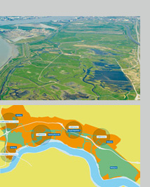
 Peterborough Integrated Growth Study
We led a 20-person team of planners, economists, transport planners and engineers, sustainability, energy and cultural specialists, urban designers and delivery specialists over a 9-month period that prepared the Integrated Growth Study (IGS) for Peterborough City and district for Opportunity Peterborough (OP). The study sought to provide an overarching framework for growth of 25,000 new homes and 20,000 new jobs over the period 2001 – 2021 and to 2026 for housing; and, for its regeneration. The work substantially informed the Council’s Core Strategy and guided the subsequent City Centre Area Action Plan. The IGS represents a breakthrough in approach. It incorporates a robust planning approach rooted in a sound evidence base, in depth community consultation, and a rigorous and transparent methodology, while being imbued and driven throughout by sustainability and setting targets for improved performance. It combines vision with evidence, originality and innovation, while considering feasibility and viability and sets out comprehensive delivery strategies. Regular meetings with the Chief Executive and senior staff of Opportunity Peterborough (OP) and of Peterborough City Council and made presentations to the OP Board and Council Committees.
The work in 2007 and early 2008 involved a substantial evidence base of 300 documents that were reviewed, supplemented by 36 GIS spatial baseline maps of natural resources, infrastructure and the socio economic context, which led to detailed constraints and opportunity mapping and all matters were distilled into 50 overarching issues. A Vision and Objectives were developed, along with economic scenarios and supported by an Integrated Resource Management model (IRM). IRM was a tool that recognises the links between environment, sustainability, resource use and development and links spatial information with performance-based data to calculate performance measures across alternative growth options. Three growth options were evaluated in detail leading to the recommended option that was incorporated into the Core Strategy. This was supported by a range of delivery strategies for supporting transport, utilities and social infrastructure. A key original proposal was for a Sustainability Charter – linking the proposals into an overarching mechanism, setting out key drivers for growth, timelines and a monitoring system of unprecedented depth to measure and drive changes.
Within the RTPI’s East of England Regional Planning Achievement Awards 2008, the project was highly commended by the judges and awarded third place in the competition.
On 13 September 2011 this Study was mentioned in the House of Commons by Stewart Jackson MP, who talked about how it demonstrated that the city could meet its ambitious growth targets whilst still achieving environmental, economic and social sustainability. Furthermore, the report at the time highlighted that datasets from the Study have been used to underpin the pioneering ‘Peterborough Model’, a web-based visualisation of the city-wide environmental performance. The Study, developed through a public-private collaboration, had received interest from as far afield as New York, Cape Cod and Bordeaux, as well as from HM Treasury to support the Green Infrastructure Plan.
 London Riverside Development & Regeneration Framework
We co-directed the preparation of a Framework for the London Riverside area within the London Thames Gateway to secure its physical, social, economic and environmental regeneration. The area is 15 sq. miles (some 3,000 ha) covering an area 10km long within three local authorities. The Steering Group included LTGDC and its partners: the London Boroughs of Newham, Barking & Dagenham and Havering, GLA, LDA, Transport for London, English Partnerships and London Riverside Ltd. Regular meetings with the Board members, Chief Executive, Directors and senior staff of the London Thames Gateway Development Corporation and senior representatives of the Steering Group and presentations were made to the LTGDC Board.
The 2006 Framework provided for over 30,000 new homes, 10,000 new jobs, transport improvements, parks and open space, social infrastructure, town and district centres and waste and utilities upgrades. The work provided a comprehensive baseline study setting out all relevant evidence and key issues, a Vision and development principles, proposals for sectoral development, 11 sub area proposals and implementation and delivery mechanisms. The work involved leading and coordinating four other specialist consultancies in transport, environment and flooding, urban design and property market. It is currently being converted into an Opportunity Area Planning Framework through the LTGDC and GLA.
Although the Framework was produced from March 2005 and finalised/approved by LTGUDC in January 2007, it was not until 2011 and then February 2015 that the GLA published the draft Opportunity Area Planning Framework (OAPF) for that area, covering 3,000 hectares with the capacity for 26,500 new homes and 16,000 jobs. The early completion of the 2007 Framework, therefore, led the way in developing the OAPF and in developing this area of London.
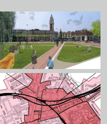 Brixton Town Centre Visioning Framework
We led the preparation of this Visioning Framework was to identify regeneration priorities and development opportunities in Brixton’s town centre and was the foundation document for a Masterplan for Brixton Town Centre. Based on a thorough document review, as well as key issues analysis, a review of existing and emerging trends, a transport analysis, major planning application analysis to identify specific sites and review development potential, property market trends analysis and land ownership study. A Vision was developed that guided a strategic framework for the town centre, together with six sub area frameworks, initiatives and a range of projects.
The work, undertaken during 2007, involved leading and coordinating two other specialist consultancies in urban design and property market. The resultant projects covered culture and identity, economic regeneration, social infrastructure and housing. Using these projects, recommendations were then also made regarding governance, management and funding over three time scenarios. Subsequent public consultation took place on this work as a preamble to developing the Town Centre Masterplan and incorporating appropriate planning policies into emerging documents.
 Hendon & East End Regeneration Framework, Sunderland
We led the preparation of a Framework, following completion of a Neighbourhood Renewal Area survey, to guide the regeneration, management, promotion and, where appropriate, the redevelopment of the area. The work was undertaken for ‘Back on the Map’, the NDC Partnership, with assistance from the Sunderland City Council (SCC). The work, spanning 4 years from 2005 – 2009, due to the NRA survey, included a comprehensive baseline study, which SCC will be using as an input to their Core Strategy evidence base. It also included several stakeholder and public consultation events, an Issues and Options stage, a new Vision for the area and the final report. Finally, a Delivery Strategy was prepared setting out the current economic context, public and private sector funding opportunities, potential delivery mechanisms and schedules of project phasing and funding.
The work involved leading and coordinating two other specialist consultancies in urban design and property market. Back on the Map want this work to help to shape the future of this area post 2011 when their functions end. SCC are currently exploring ways to incorporate the Regeneration Framework into the planning system, such as the use of the Baseline Report within their evidence base and to shape emerging policy, conversion of the Framework into an SPD or its conversion into a Community Plan.
 Weston Super Mare Area Action Plan
We led the development of the 2005 existing Weston Area Development Framework (WADF) into an Area Action Plan (AAP) to form one of the largest AAP’s in the UK under the 2004 PPS 12. This work, undertaken during 2006 and 2007, was extensive and commenced with a ‘Compatibility Assessment Report to determine how the WADF could be used in the WAAP process. This was followed by a comprehensive baseline exercise that kept pace with the rapidly changing policy environment at that time. This included an extensive document review, socio-economic assessment, transport review, property market analysis, community facilities review, environment and utilities review and an urban design review, all summarised in an Overarching Evidence Report. It was supplemented by a Sustainability Appraisal Scoping Report. A Vision and Options Report that set out a new strategic spatial vision, four spatial options and their detailed evaluation and an outline of the Preferred Option was prepared. A Consultation Statement of Compliance was prepared that set out the legal requirements, methodologies, the consultation undertaken, the bodies consulted with and the key issues raised and their contribution.
Finally, the Preferred Options Report was prepared that summarised the process, described the Preferred Strategic Spatial Option in some detail, set out the necessary policy considerations, delivery mechanisms, the monitoring framework and the recommended next steps.
Soon after its completion, the Council decided to split the AAP into two separate but related areas (Town Centre and the Regeneration Area), which meant reworking the AAPs as separate documents. Work is ongoing on the development of the Town Centre AAP.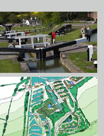 Foxton Locks Masterplan
Foxton Locks is an historic site of eight hectares and is located on the junction of the Leicester line of the Grand Union Canal and the Market Harborough arm. The locks were originally constructed between 1811 and 1813 and are now home to the longest flight staircase of locks on the UK waterways system, the now largely derelict Foxton Incline Plane, which is a Scheduled Ancient Monument.
During 2005, we led the preparation of a masterplan and implementation strategy to develop an improved tourist destination based on the historic importance of the area and assist in attracting funding for improvement works for British Waterways, with the assistance of Harborough District Council. The work involved an analysis of visitor profile and needs, site analysis, the development of masterplan concepts, consideration in more detail of transport and environment issues and proposals, a planning history and policy review and recommendations on the most appropriate planning framework to deliver the masterplan. The Implementation Strategy set out a planning policy strategy, priority project definition and a phasing and funding strategy. It finally set out a 10-step Action Plan, a rolling programme of actions for clients and partners.
The Masterplan was commended in the Strategy and Masterplanning category at the BURA Waterways Renaissance Awards 2006. Subsequently, in 2010 a new Heritage Partnership Agreement (HPA) was signed for a 5-year period between British Waterways, English Heritage, Harborough District Council and Leicestershire County Council. The agreement sets out which works require planning consent and which are permitted works and signals a change in the way the site is managed. The site is classed as a designated Conservation Area containing a Scheduled Ancient Monument with a number of Grade II and II* listed buildings and attracts over 300,000 visitors per year.
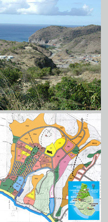 Little Bay Town Centre Action Area Plan, Montserrat
During 2001 – 2002, we led the preparation of the Town Centre Action Area Plan for the Government of Montserrat. This work was required following three hurricanes and devastating and continuing volcanic eruptions that destroyed the island’s 400 year old capital, Plymouth, and made two thirds of the island uninhabitable. Following this, a new location for the capital town was selected and this plan was to be prepared following an international tendering process funded by the Government of Montserrat and the Caribbean Development Bank.
The work was undertaken in the UK and with three island visits, each of several weeks. The work had three main stages over a period of a year. The Inception stage involved methodology development, establishing the role and content of a town centre, extensive consultation meetings, describing the key issues and commenting on these issues – all with the client’s agreement. The Interim stage involved setting out the results of the data review and baseline audit, establishing key constraints and opportunities, formulating preliminary development options, assessing implementation (overseeing agency and roles for Government departments) and funding sources and mechanisms. The Final stage involved describing the option development and refinement process, setting out the Preferred Option with its phasing and programming and detailed plans, setting out infrastructure requirements and broad costs, undertaking a Strategic Environmental Assessment (SEA), Design Guidelines for the AAP and setting out recommendations for implementation, funding, revenue and investment. This final part involved detailed expected costs and revenues, budget requirements and three investment brochures for advance development packages.
The work involved leading and coordinating a team of 10, including two other specialist consultancies in engineering and utilities and architecture over a one year period. Regular meetings with the Chief Minister, Ministers, senior staff of the Government of Montserrat and key stakeholders were held. The work is specifically referred to in the Montserrat Sustainable Development Plan 2003-2007, many of its recommendations have been carried forward in subsequently planning and implementation and recently the Montserrat Development Corporation was set up, as recommended in the AAP.